
Related:
I find it absurd that educated people writing research based articles for top magazines think Graham Hancock is full of bullshit and is just a psuedo archaeologist with no evidence. The evidence he presents, both from research into discoveries before him and by exploring underwater structures himself, is more than just compelling. Its stuff that should give anyone pause and wonder how many more structures must be underwater from the last ice age.
The one shining light for my interest in archaeologists looking for underwater monoliths/structures is that the archaeologist currently in charge of excavating the 12,000 year old Gobekli Tepe stated in an interview that Gobekli Tepe is probably just something we discovered and is not the first of anything. My take is that: Other such structures may have been destroyed or haven't been found yet or some structures may simply be underwater which humans, being land mammals, fear to venture into. There is alot more to be discovered and its underwater.
To assume that anything found is the first of EVERYTHING is how archaeologists came to assume that settlers invented agriculture and architecture till they found Gobekli Tepe. Then, just as fast, they assumed it was Gobekli Tepe and religion that started architecture and agriculture. Its more likely that cultures existed throughout the region. And someone clearly had reached the ability to make maps in that era as you will see. And making carvings out of stone was probably common in many areas, especially those underwater now.
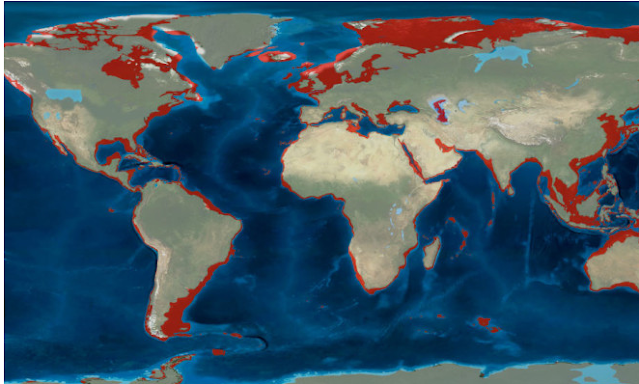
Before the video for this post I would like to point out that archaeologists are beginning to do underwater archaeology in some areas that are close to their homes and a very intelligent article came out in discover magazine a couple of years ago, which hasn't permeated the field yet (as it appears to be with most discoveries in archaeology). The article points out that over a continent in land area has been lost to rising sea levels and that since the coastlines are the most desired real estate by humans, THATS where many of the best future discoveries about human history will be made. A screen shot and tiny extract from that article to make that point:
Discover Magazine: Rising Seas Swallowed Countless Archaeological Sites. Scientists Want Them Back
The article points out that:
Just as today’s human populations cluster along coastlines — nearly half of us globally live within an hour of a coast — our ancestors likely did as well. These lost regions are not merely stretches of continental shelf now underwater, but rather resource-rich ecosystems and corridors once used for exploration by early humans.
“If you look at the factors that drove our evolution, a lot of them were coastal,” Dobson says. For example, the richest sources of the element iodine — essential for our thyroids to function — are fish, seaweed and shellfish. “Iodine is a coastal resource,” he says. “We have to have it to survive. We’re dependent on it.”
Hunters and foragers on the coasts would have enjoyed the best of both worlds, terrestrial and marine, with access to fresh water, land animals and plants as well as shellfish, seaweed, seabirds and fish.
The appeal of coastal living is not just limited to humans, either. “If you look at ecological data for mammals, both herbivores and carnivores occur in greater densities in coastal regions,” says Bailey.
He adds that glacial maxima, when ice sheets were expansive and sea levels fell, typically meant global shifts to a drier climate that could have made inland areas less habitable.
“During periods of lower sea levels, those coastal regions would have been particularly attractive because they generally coincide with periods of greater aridity in the hinterlands,” Bailey says.
The article even points out that migration may have taken a sea route making having a land route through the ice irrelevant and provide another reason for travelers of that time in coastal communities having maps;
The conventional view of the first humans to reach the Americas is that they arrived from Siberia, bundled in furs and tromping across the steppes of Beringia, no more than 13,500 years ago. After crossing the land bridge, they followed an open corridor between two shrinking ice sheets into the continent’s interior.
But recent geological and paleoenvironmental studies, such as a reconstruction of ice sheet ebb and flow published in Science in 2017, have suggested that this corridor would not have been habitable until centuries later, long after humans were already present throughout the Americas. Plus, sites from Chile to Florida have been dated as at least 14,500 years old.
First proposed about a decade ago by University of Oregon archaeologist Jon Erlandson, the Kelp Highway Hypothesis suggests that, millennia before the inland Beringia land corridor opened, humans could have followed resource-rich paleocoastlines by boat. This route would have taken them from Asia and Siberia eastward along the southern coast of Beringia, into the Americas, and all the way to southern Chile. The idea is gaining momentum.
“We’ve been talking about the ice-free corridor for 80 years,” says Todd Braje, California Academy of Sciences archaeologist who believes a coastal route was open at least 16,000 years ago and possibly much earlier. “It is time to explore other things.”
One more thing. The map evidence in the following video - which I consider to be conclusive as to a previous map making culture around the time of Gobekli Tepe - is not from Graham Hancock but older evidence, that Einstein appeared to have taken seriously, documented by Charles Hapgood. Here is an extract about the book from Amazon.com:
Book Abstract from Amazon: Charles Hapgood’s classic 1966 book on ancient maps is back in print after 20 years. Hapgood produces concrete evidence of an advanced worldwide civilization existing many thousands of years before ancient Egypt. He has found the evidence in many beautiful maps long known to scholars, the Piri Reis Map that shows Antarctica, the Hadji Ahmed map, the Oronteus Finaeus and other amazing maps. Hapgood concluded that these maps were made from more ancient maps from the various ancient archives around the world, now lost. Hapgood also concluded that the ancient mapmakers were in some ways much more advanced scientifically than Europe in the 16th century, or than the ancient civilizations of Greece, Egypt, and Babylonian. Not only were these unknown people more advanced in mapmaking than any people prior to the 18th century, it appears they mapped all the continents. The Americas were mapped thousands of years before Columbus. Antarctica was mapped when its coasts were free of ice. There is evidence that these people must have lived when the ice age had not yet ended in the Northern Hemisphere and when Alaska was still connected with Siberia by the Pleistocene, ice age “land bridge.â€
Now I'll let Hancock outline the theories and discoveries he's made.
Graham Hancock: A Species with Amnesia FULL LECTURE Megalithomania 2009


This carved out structure reminds me of Karahan Tepe as I pointed out in an earlier post.


The mystery of the Piri Reis map is covered by this article by History Daily. The article closes off poorly but covers some important points bout the map indicating it must have been drawn before the rise in sea level... and possibly before a comet hit and caused an earth crust displacement, which Hapgood and Eienstien theorized may explain the ancient maps.
Ancient Map Shows Antarctica Coastline Without Ice
A medieval-era map, discovered in a Turkish palace in 1929, is dated 1513, yet it shows a knowledge of faraway lands well beyond the areas European explorers had traveled and even shows land features Europeans couldn’t possibly of known about in 1513…like the Andes Mountains of South America and the coastline of the Antarctic under the ice. The map, drawn on a piece of gazelle skin, was said to be the work of Piri Reis, a cartographer and admiral in the Turkish army. The amazing accuracy of the Piri Reis map has scholars scratching their heads. Is the map proof of an ancient, yet advanced, seafaring civilization?
Piri Reis Cited His Sources
When drawing up his map, Piri Reis consulted as many as twenty other maps, some dating back to the time of Alexander the Great. The cartographer was careful to note his sources on his map, which he dated 1513.
The Piri Reis Map Shows the Antarctic Land Mass
Antarctica is more than 98-percent covered in glacial ice and snow. The continent of Antarctica was discovered in 1818, several hundreds of years after the Piri Reis map was drawn, yet it shows a land mass where Antarctica is. This, in and of itself, is astonishing, but there are more curiosities. The coastline of this land mass was unfamiliar and therefore deemed inaccurate, for hundreds of years until 1961. It was then that Captain Lorenzo W. Burroughs, a captain in the U.S. Air Force cartography division, noted that the outline of this southern land mass seemed to accurately depict the coastline of the continent under the ice.
How is this possible, given the limitations of the surveying equipment in the 1500s? One theory is that the map was drawn using information on older maps that were made so long ago that it was before Antarctica was covered in ice. If that is the case, it is proof of an advanced, and much older civilization that pre-dates known civilizations.
The Piri Reis Map Shows Antarctica Attached to South America
One odd inaccuracy in the Piri Reis Map is that the tip of South America is attached to Antarctica. One theory to explain this connects to the idea of continental drift, the belief that all of the continents once formed a giant land mass that has split into small land masses and drifted to their present locations via plate tectonics. It is theoretically possible for Antarctica to have been attached to South America, just as the Piri Reis Map shows, in the distant past and that is broken off from South America and formed its own continent after pre-historic seafarers charted this part of the globe. Even if this shift was the last breakage of the original giant land mass, it still would have occurred much longer ago than known human exploration.
The Map Notes the Arctic Winter
Piri Reis added a note on the map he created that translates to say, “It is related by the Portuguese infidel that in this spot night and day are at their shortest of two hours and at their longest of 22 hours.” Due to the tilt of the Earth, the winter months in the polar regions receive very little, if any daylight. During the summertime, however, the sun never sets and the region experiences constant sunlight. Piri Reis indicates that he was given knowledge of this from the Portuguese, but no known Portuguese sailor had ventured that far south in the 1500s. Oddly, Piri Reis positioned this notation near South America, much further north than the regions affected by the polar winter. It could be that he simply added the notation where there was room. Other experts believe that South America was once further south of its present location and has since drifted north.
The Piri Reis Map is Amazingly Accurate
The coastlines of South America and Africa, as shown on the Piri Reis Map, as surprisingly accurate…within a half a degree of longitude. The Equator is also in the precise location. Prior to 1790 when the marine chronometer was invented, sailors, navigators, and cartographers had no accurate way to accurately pinpoint a given location, yet the Piri Reis map seems to have done that long before it was possible.
Read more by clicking link above.
The evidence for a past culture or past cultures with extensive knowledge of carving structures from stone and making maps is pretty clear. How advanced do you need to be to make these structures or maps, really? I think semi settled hunter gatherer communities could be this advanced. They are humans after all.
No comments:
Post a Comment